|
|
| | HOME | ABOUT EMS | EVENTS | OPPORTUNITIES | PROGRAMMATIC AREAS | INFO-EMS | | |
| ESPAÑOL | PORTUGUÊS | |||||||||||||||||||||||||
|
INTEGRATED ENVIRONMENTAL MANAGEMENT SYSTEM (SIGA) Authors: Prof. Gabriela Fernández Larrosa, B.A.
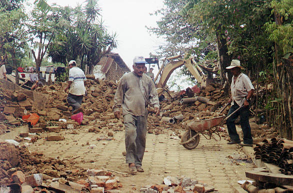
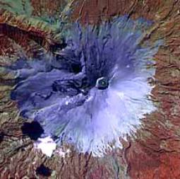
The Latin American hemisphere has been and still is a scenario for risks and disasters of different origin and intensity, most of the time unfolding as a successive chain of events. The most notorious of such cases are those whose intensity (earthquakes, volcanic eruptions, tropical cyclones, tsunamis) cause the greatest harm and loss, and take place in tectonic unstable areas -as is the case of Andean countries-and the tropical humid areas of the Caribbean. Some examples of events that turned into tragedies given the degree of harm and loss involved were: the tsunami that destroyed 400.000 homes and killed over 5.000 people in Valdivia, Chile, in May 1960; the landslide following an earthquake that affected the cities of Yungay and Chimbote, Peru, on May 31, 1970, that caused the death of most of the dwellers; the earthquake that hit part of the Mexican territory on September 19, 1985, causing 10.000 deaths and losses estimated at 5 billion US dollars; the eruption of the Nevado del Ruiz, Colombia, on November 13, 1985, that buried the towns of Armero and Chinchina whose death toll was 25.000 people.
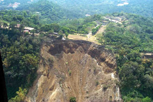
However, the whole thing is not just limited to disasters of that magnitude. There is a wide range of threats and vulnerability situations that affect our hemisphere. Some of them even take place in a spectacular way, as for example, the seasonal floods affecting the higher basins of the Paraná, Paraguay and Uruguay rivers in the southeast part of the continent. Others respond to slower processes and are, therefore, less evident -albeit not less destructive-as in the case of desertification in northeast Brazil and soil erosion processes in the humid prairies of Argentina and Uruguay. The rapid and caothic pattern of urban growth so characteristic of Latin American cities, in turn, implies an increase of technological risk. Such phenomena affect the whole of the society in countries of the region, especially those sectors that, due to coexistence of political, economic, social, cultural and geographical factors and causes, conform the so-called "vulnerable populations".
Approaches to this issue have evolved over the years, going from viewing the disasters as just the results of natural phenomena to seeing the inter-relation of different factors in the physical-natural and social environment. The latter approach handles the concepts of multi-cause, multi-scale and chain of events linking phenomena. In the case of Central America, national and international institutions and organizations have mustered enormous efforts to prevent environmental risks and disasters. These endeavours have increased manifold after Hurricane Mitch, in October 1998. For example, by the year 2002 FEMICA (Federation of Municipalities in the Central American Isthmus) monitored a sample of 27 regional municipalities on the Caribbean coast, in order to learn about their capacity to deal with and reduce environmental risks.
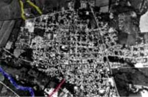
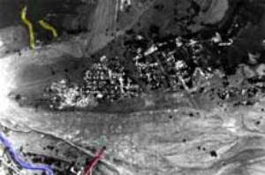
Given that all steps to prevent, handle and mitigate environmental risks and disasters are taken at the political level and implemented at the administrative level, the more knowledge available on the actual and potential scenarios, agents, causes and factors related to the advent of risks and disasters, the better the management results. However, we are aware of the macro limitations at the institutional, social, and economic levels that are beyond our scope of possibilities. Nevertheless, we do recognise the valuable contribution from the fields of science and technology when they serve society and, more specifically, the most vulnerable sectors in terms of environmental disasters. In this sense, much progress has been achieved regionally. Basic cartography has been generated covering the whole of national territories. In most cases the scale is 1:50.000, as revealed by the inventory carried out for CEPREDENAC in 1998 -though there are also examples of threat maps at more detailed scales, as is the case of Costa Rica's cantonal levels. Periodical censuses have revealed socio-economic data and databases have been prepared on the occurrence of disaster events, for example, DESINVENTAR. At the academic level there is a significative theoretical production in terms of the concepts of risk and disaster and how to approach them, as well as proposals to use geographical technologies to that end.
What is the Integrated Environmental Management System (SIGA)? The origins of SIGA relate to a proposal for land and environmental management for an urban water basin in Montevideo, Uruguay, focusing on the management of water and solid waste (González et al, 2000) and the further expansion and identification of such basin (Fernández Larrosa, 2001). These conditions are obviously different from those existing in other contexts of the Latin American continent, both in terms of weather conditions as in geo-tectonic, geological and orographic frameworks and social reality. Stemming from the aforementioned experiences this system was generated. Due to its characteristics it can be used in different environmental risk situations in Latin America. SIGA is basically an easy-to-create methodological tool that can adapt to different conditions in terms of the existing level of knowledge and the technological resources available. The SIGA takes the water basin as territorial and environmental unit. It allows to work with a considerable number of variables selected from the physical-natural environment, socio-economic, land use and the infrastructure of life lines and services available and to combine them in order to determine the risk and vulnerability levels; it can also be used to create and consult geo-reference databases. The rationale of the system lies in the fact that it considers that the environmental risk of one area results from the combination of the above-mentioned aspects and that is can be easily located and, therefore, can be expressed in cartography. Integrated Environmental Management System (SIGA) The output or final synthesis is a series of thematic maps where areas are differentiated according to their level of environmental risk to one or more threats. It must be underlined that the maps are fundamental in the spatial analysis at a detailed scale, as they synthetically represent information that serves as basis for the formulation of risk management policies and decision-making. SIGA applicability at the municipal level Local level: Risk can be expressed at different geographical scales. Though its origins are located at another scale, it manifests most clearly -and in some cases more painfully-at the local level, where it is more feasible and practical to weigh risk, coordinate and act. The local government is organized in terms of the territory on the basis of an administrative unit called Municipality. In fact, at the time of Hurricane Mitch, the municipalities hit in Honduras and Nicaragua were the ones who tackled with the problem directly and sought solutions. A similar situation is experienced when floods of greater impact and frequency affect the northeast and Pampa regions of Argentina, having an impact on the most important urban centres, including the Buenos Aires metropolitan area. Another example is the landslides in the Belo Horizonte Municipality in Brazil, resulting from heavy downpours that affect "favela" dwellers. However indispensable it may be, the best step is not the one taken after the event but rather the one prior to it. In the past, the strategy to approach disasters consisted basically on post-impact humanitarian aid; at present, emphasis is placed on reducing and managing risk. At the municipal level support in terms of evaluating risk and the preparation of plans to reduce risk as part of environmental management, need to develop further. Accordingly, SIGA is considering anticipating the effects that an environmental disaster could potentially generate. It is also useful to generate an appropriate post-event response and to implement mitigation measures. Geographical scales between 1:50.000 and 1:10.000 -in a gradually increasing detail--, adequate to represent the area covered by municipalities in Latin America, also allow for vulnerability, threat and risk to be seen in their true dimensions and characteristics. Thus the need for analysis and organised intervention promoted from the local and the community. SIGA was generated and is conceived to work at these scales. Decentralization: Political and administrative decentralization is a key element in the process of democratic consolidation throughout the hemisphere. Thus among the proposals presented by the Central American Integration System during the Consultative Summit in Stockholm (1999), capacity building of institutional management appeared both at the level of regional and national institutions responsible for risk management, as well as in the case of affected communities that need to increase their capacity to respond. Providing municipalities with a tool that allows them to manage risk represents a concrete contribution of science and technology to the decentralization effort. Methodology: Descriptive, analytical and evaluation tools have been created in Latin America to face environmental risk situations. However, there are no methodologies to approach risk evaluation more closely and with an integrating approach. The pervasive vision is still that of the "natural" disaster. In turn, we have detected problems in terms of the quality and compatibility of cartography, outdated information, and different kinds of coverage and availability of information on social variables. On the other hand, there are few references in current literature related to the analytical approach to geographical space in terms of vulnerability. The SIGA tool features the following advantages: requires data that can be easily generated and collected in the region, even data already available; low cost of implementation; adapts to a whole range of conditions in terms of level of knowledge and technology available; can be applied to different geographic contexts. It must be pointed out, however, that SIGA is not a GIS, though the use of a GIS is suggested in case the municipality has access to such a system. In addition, SIGA does not replace fieldwork, or knowledge of background on phenomena generating environmental risk in each community. On the contrary, that input is fundamental for the SIGA to work. | ||||||||||||||||||||||||
|
|
|
|
HOME | ABOUT EMS |PROGRAMMATIC AREAS | EVENTS | FUNDING | CALLS FOR PROPOSALS | INFO-EMS BULLETIN |
|
|
|
|