|
A
case study
GIS and Proposal for Territorial Planning at the Malvín Brook Basin,
Montevideo-Uruguay.
by
Prof. Álvaro González-Gervasio and Gabriela Fernández
Department of Geography
Faculty of Sciences, Universidad de la República
Introduction.-
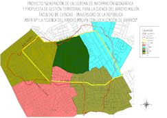
The Malvin Brook Basin is located at the south east of Montevideo City,
within a total area of 828 hectares. Nowadays about 60,000
persons inhabit the area. By 1950 the basin was occupied by idle
lands, farms and stone quarries. Significative changes in the soil use
took place since: middle class houses were built in the southern section
of the basin, complex of buildings spread in the northern section, while
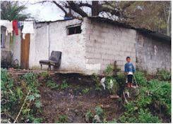
shanty towns began to occupy the borders of the brook and dells, and the
site of abandoned quarries. The rest of the basin is occupied by idle
lands with no defined functions.
Such
changes led to the progressive degradation of the area from the
environmental and social point of view. In the meantime the upper and
lower courses of the brook were covered and substituted by streets, and
the middle course –where at present social and environmental problems
concentrate- was rectified. The existence of several educational
institutions and sport infrastructures, as well as the new location of
the Faculty of Sciences can be considered positive elements in this
context.
Activities
of the Project.-
1) Delimitation of the basin (study area: 570 hectares). 2) Documentary
revision. 3) Interviews to satakeholders. 4) Chemical analysis of water.
5) Survey of the state of streets and pavements. 6) Design of the
GIS. 7) Elaboration of the proposal for territorial planning.
Conflicts
detected.-
a) Non-planified soil use. b) Pollution of organic origin
due to the lack of connection to the sewage systems or to breakages in
the pipes, which affecting the quality of the hydrological network. c)
Growth in the volume of garbage that is classified at some of the
shanty towns. Undesired material ends in the brook and dells. d) Loss of
the esthetic quality of the landscape.
Main
causes of the existing problems.-
1) Even though the sewage system exists, about 50% of the homes are not
connected to it. b) Inadequate maintenance of the sewage system.
c) Garbage disposal and transportation is irregular. d) Weak
social interactions due to the difference among the groups
coexisting in the area (there is not a sense of community).
Original
aspects of our research.-
a) Systemic approach since both socioeconomic and physical
aspects of the basin and their interactions were taken into account.
This is not usual in urban basins. b) New information at a detailed
scale was generated. c) The past and expected (with and without
planning) dynamics of the area were considered, as well as the
generation of possible scenarios.
We
think that this kind of approach and methodology can be applied to
similar cases existing in urban environments in the region.
Mapping
of environmental risk.-
The environmental risk depends on the intensity of the factor
considered as a menace, and the vulnerability of the affected element.
We have chosen 2 physical aspects (landform and distance to the
brook), which combined with 3 socioeconomic aspects (presence or
absence of sewage system, health cover and number of people per home),
resulted in 3 levels of environmental risk: low, medium and high. The
area bordering the creek, and those occupied by the shanty towns Aquiles
Lanza and La Cantera were defined as prone to high environmental risk.
Proposals
for territorial planning.-
1) Descentralization of the activities of maintainance of the
sewage system, in order to give a quick response to urgent problems
(e.g. pipe breakage). The descentralization process started by the
Municipality of Montevideo more than a decade ago can be a positive
input to this regard. 2) Coordination of the municipal agencies
devoted to environmental services. 3) Give priority to the areas
considered of “high
environmental risk”, taken into account the differences existing
among them. 4)
Implementation of a specific plan regarding garbage production,
classification and transportation. |